

Weather forecasters are maintaining a view the Ohio River will not exceed minor flood stage by the time it crests on Tuesday. Thunderstorms heading our way may alter that forecast should they stall or change direction.
The Ohio River level at Lewis County is expected to be in the 56 foot range by the time it crests here on Tuesday, according to officials with the National Weather Service in Wilmington, Ohio.
On official with Kentucky Emergency Management said the expected flooding will “not be quite as significant at the 1997 event but it will be very close.
Since that time, FEMA has purchased many affected properties and residents in the flood-prone areas have relocated.
Judge Executive Todd Ruckel says local officials are prepared for the minor river flooding and are also prepared should weekend rains result in any additional flash flooding in the county.
Ruckel said emergency shelters can be activated on short notice should the need arise and added road crews will be on standby to make any emergency repairs to roadways, culverts and bridges, if needed.
Emergency Management Director George Sparks said the latest forecast is welcome news and added he will continue to closely monitor the weather situation and will be prepared with any appropriate response.
For information or assistance call the Lewis County Emergency Management Office at 606-796-3464. In an emergency call 911.
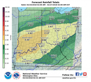
National Weather Service officials have said we should expect several rounds of prolonged moderate to heavy rainfall for the area through the weekend. There will also be some high winds associated with the incoming cold front.
“Specific river forecasts are highly dependent on exactly where the rain footprint is placed, which leads to a lower confidence in the exact crests that are being forecast,” according to an official with the NWS office in Wilmington, Ohio.
Embedded thunderstorms are possible tonight, according to the latest precipitation forecast. Some of the storms may be capable of producing damaging winds after midnight.
Current watches and warnings for Lewis County:
FLOOD WATCH REMAINS IN EFFECT THROUGH SUNDAY MORNING…
The Flood Watch continues for
* Portions of Indiana, Kentucky, and Ohio, including LEWIS COUNTY
* Through Sunday morning
* More rainfall is expected, with the potential for heavy rainfall at times today and tonight. Additional rainfall amounts of 2 to 3 inches will be possible.
* Excessive rainfall will cause local rivers, creeks, and streams to rise. Those near streams and rivers should be especially cautious as streams and rivers can rise quickly.
Instructions: People in the watch area, especially those living in areas prone to flooding, should be prepared to take action should flooding develop.
Monitor the latest forecasts and be alert for possible flood warnings.
**
The Flood Warning continues for the following rivers…
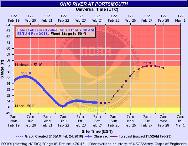
Ohio River at Portsmouth
Ohio River at Vanceburg
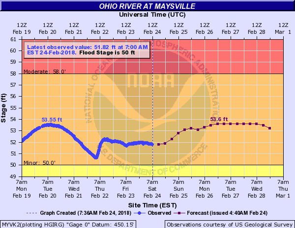
Ohio River at Maysville
* Minor flooding is occurring and Minor flooding is forecast.
* The river will rise to near 56 feet by Tuesday. The river will then begin falling, but remain above flood stage for the next 5 days.
**
SEVERE THUNDERSTORMS POSSIBLE TONIGHT…
An advancing cold front will combine with strong upper level dynamics to bring a chance of severe thunderstorms to the region tonight. The best chance of severe weather will be between
midnight and 7 AM Sunday morning. The greatest threat from the storms will be strong damaging winds and very heavy rain, however an isolated tornado cannot be ruled out.
Stay informed with updated forecasts along with statements and possible warnings for the latest on this severe weather threat.
**